Broadway, Main and Third Street
Kendall Square Urban Redevelopment Area - Conceptual Streetscape Redesign Project

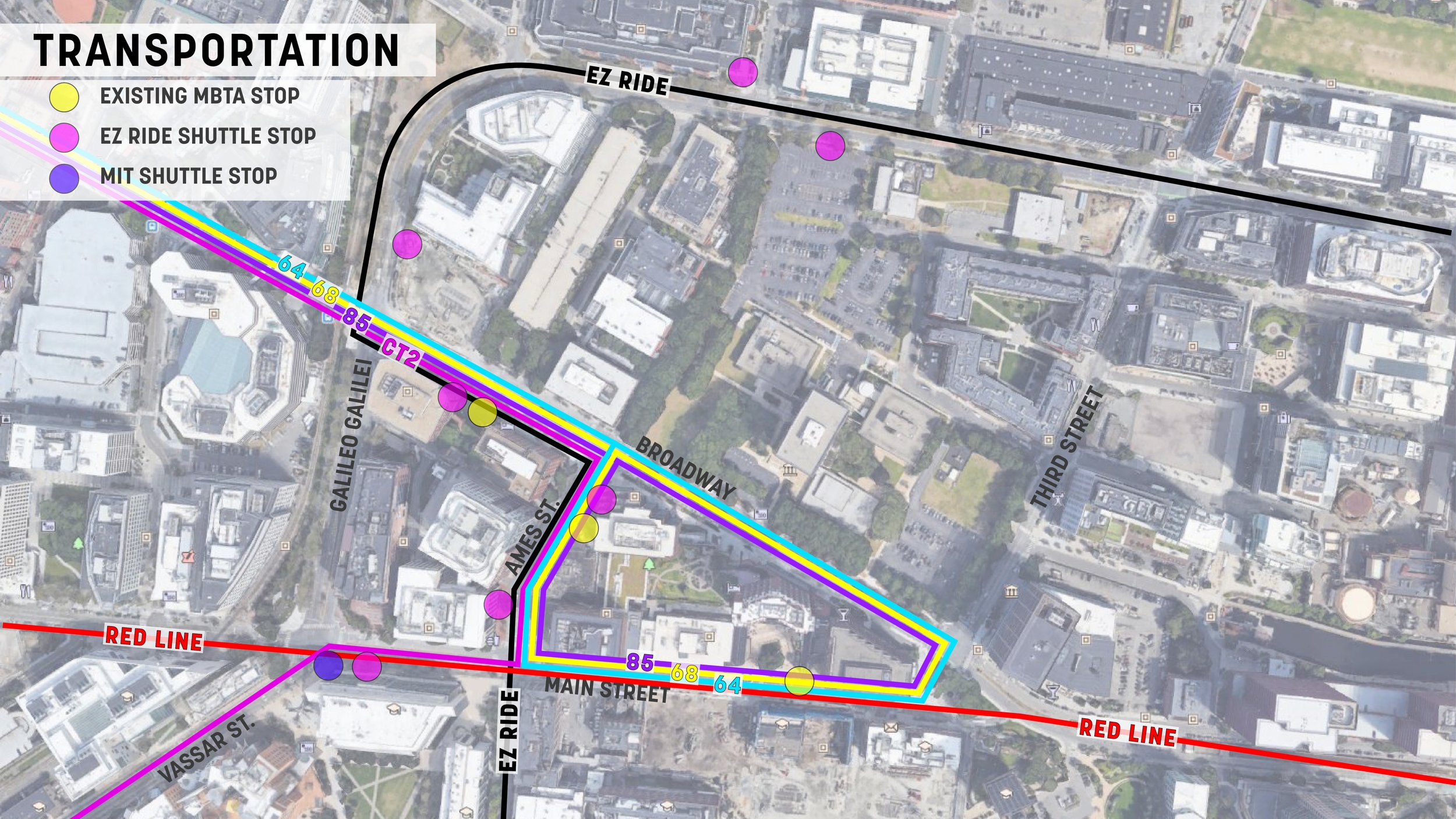
People moving on Main Street in Kendall Square by foot, bicycle, private vehicle, and public transit.
About the Project
Over past years, many streets in the Kendall Square area have been retrofit or rebuilt, often reducing travel lanes and expanding facilities for pedestrians and bicyclists. The CRA has worked to develop these changes into a coordinated streetscape network throughout the area, and we have now developed conceptual streetscape designs for Broadway (Ames Street to Galaxy Park), Third Street (from Galaxy Park to Binney Street), and Main Street (from Vassar Street to Galaxy Park).
The concept designs established here ensure continuity among any future streetscape reconstruction in the KSURP area. Each team moving forward with these plans over the next few years should refer to the design guidelines, analysis and recommendations included in this document, and remain abreast of the evolving future of Kendall Square. The goal is to connect existing and planned streetscape infrastructure in Kendall Square and holistically incorporate the region’s vision of a multi-modal transportation network with context-specific amenities and landscaping.
This process was conducted in collaboration between the CRA, the City of Cambridge Department of Public Works (DPW), Cambridge Traffic Parking & Transportation (TPT), and the Cambridge Community Development Department (CDD). The designs here were developed with input from property owners, transportation providers, stakeholders, and the community to ensure the designs align with existing uses and future development plans.
A brief highlight of the report’s key outcomes is shared below, and for more information on the process and findings please view the report, available now.
READ THE REPORT
All sections, with appendices
Report by Section
BMT KSURP Report, Sections 1-3
Introduction, Process, and Design Analysis & Criteria
Existing Conditions
Streets
Intersections
BMT KSURP Report, Sections 7-8
Design Elements & Conclusion
Design objectives
Implement separated bicycle facilities where feasible, as per the Bicycle Network Vision and the Cycling Safety Ordinance
Accommodate access to new and existing developments
Plan around existing and future stormwater and utility infrastructure
Preserve and enhance the tree canopy
Improve pedestrian and bike infrastructure at intersections
Design for bus/shuttle priority and access to Kendall/MIT MBTA Station
Design for pick-up/drop-off and commercial loading zones
Activate streetscapes with retail
Existing Conditions
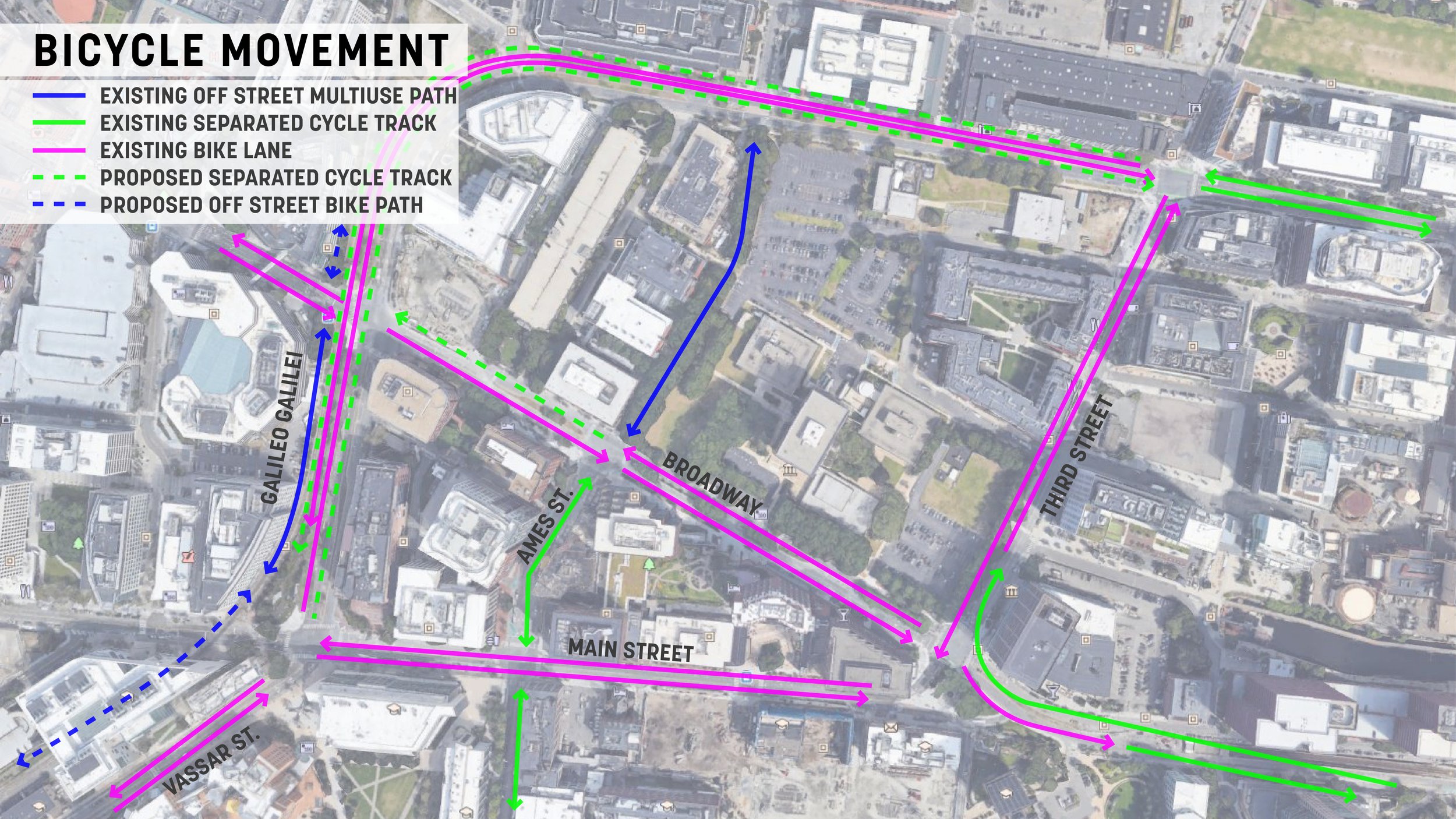
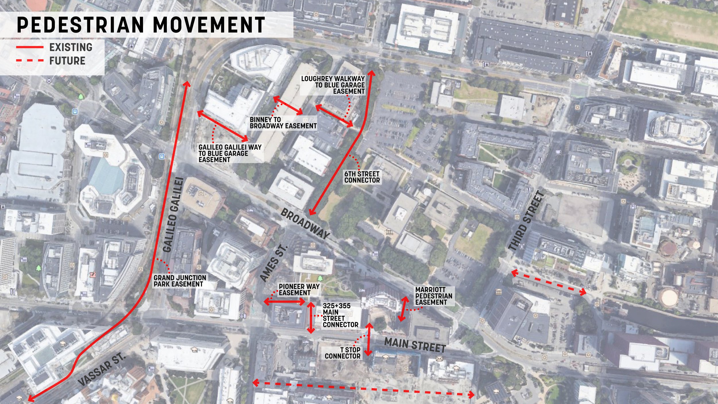
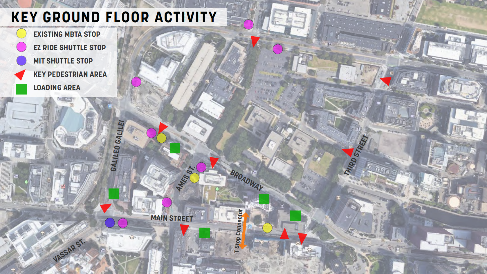
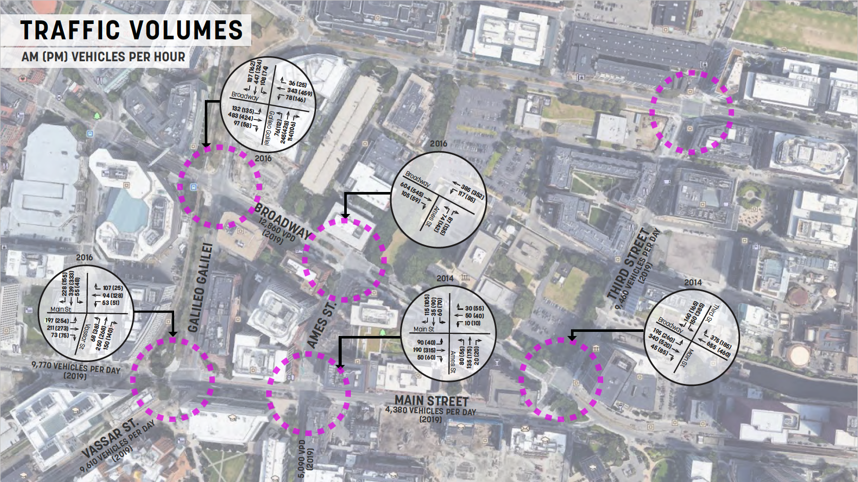
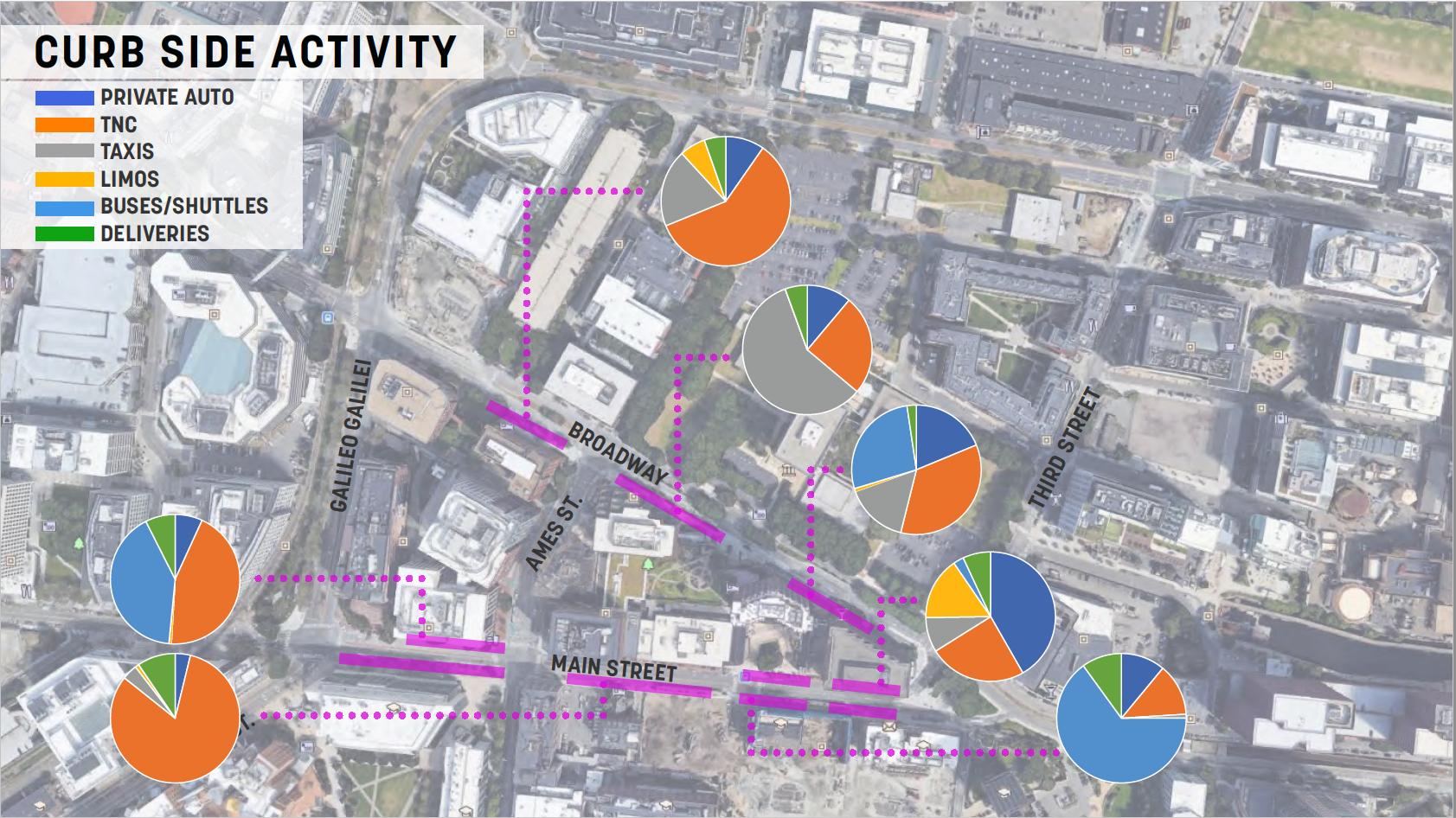
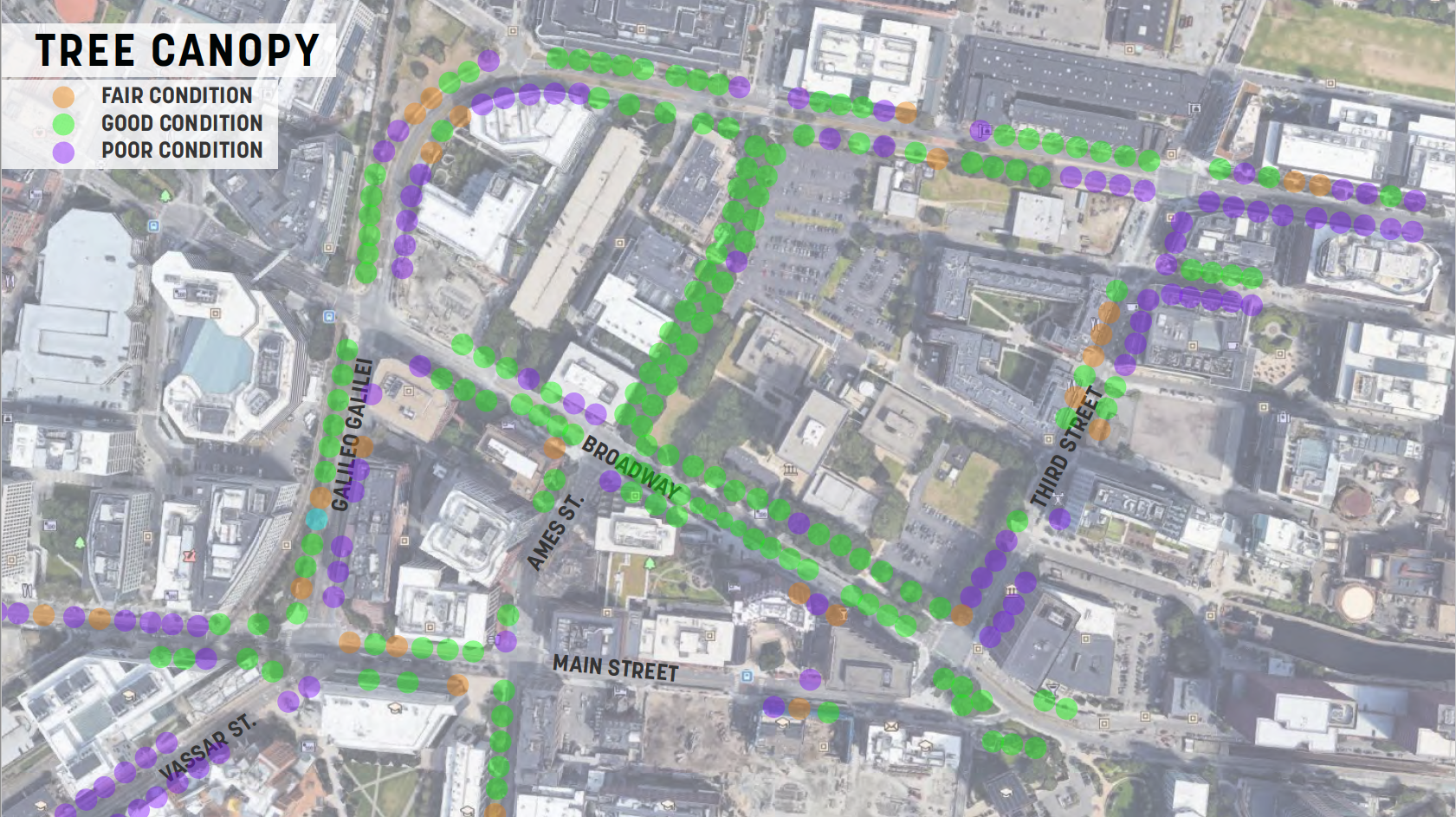
Diagrams of Existing Conditions & Movement Patterns through Kendall Square.
BROADWAY
Broadway serves as a major east-west connection to and from the Longfellow Bridge to Boston. The section within the study area includes significant tree canopy. It serves as a gateway to the Kendall Square area from Boston.
GOALS ESTABLISHED WITH THE PUBLIC & STAKEHOLDERS
Expand the raised cycle track
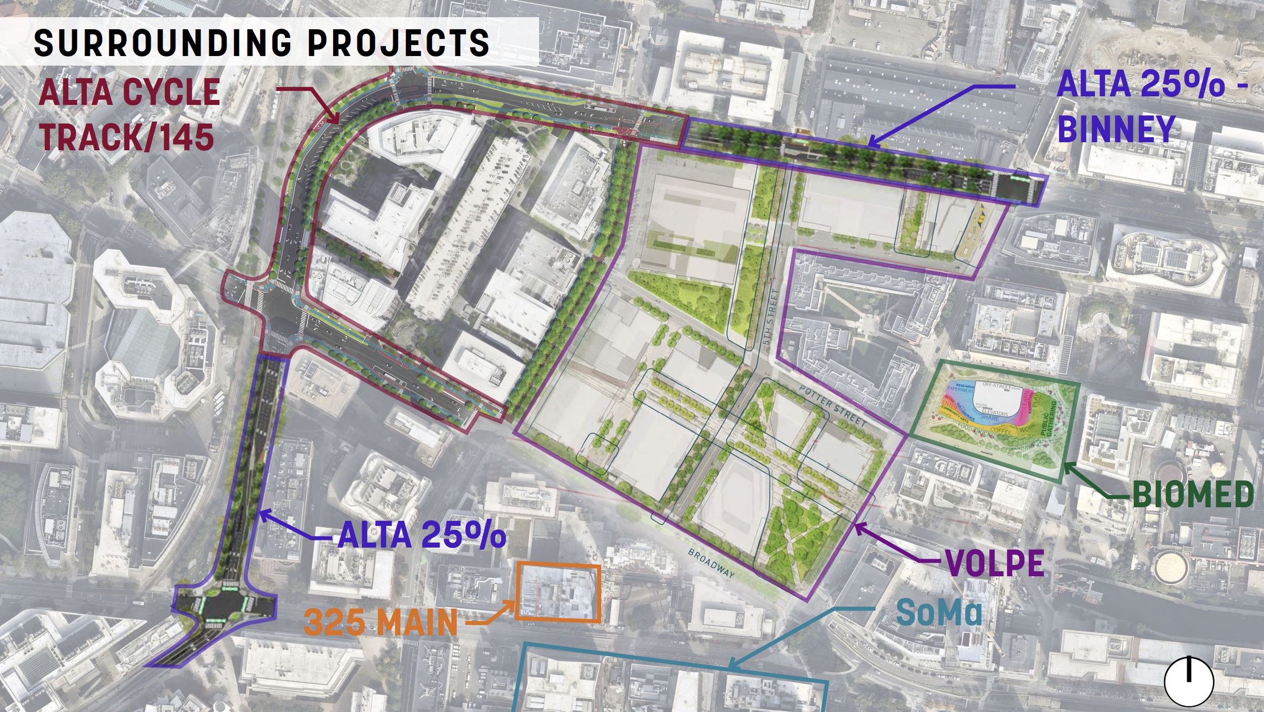
Connect into Volpe plans
Preserve existing tree canopy
Reconcile loading zones with pedestrian and cyclist experience
Continue placemaking elements begun at 145 Broadway
-
The entrance and exit into the Marriott hotel will be narrowed to reduce the pedestrian and bicycle crossing distance and improve visibility of pedestrians and cyclists to people in vehicles. The existing bus/shuttle drop-off space in front of the Marriott hotel will be removed to allow space for a raised separated bike lane, and the hotel’s drop off space will be widened to allow buses to drop off passengers within the covered area instead of using the on-street drop-off zone, which was an important desired design feature established with the Kendall Marriott Hotel during stakeholder conversations.
The existing sidewalk on the north side of the street will be relocated to the north of the existing trees, which allows the raised separated bike lanes to be located between the existing trees and the curb. This will need to be coordinated with the final plans for the Volpe project.
The width between the existing median and the curb on the north side of Broadway will not allow for on-street parking, but space for pick-up and drop-off of transportation network companies (TNC), such as Uber and Lyft, can be provided in front of the new Volpe buildings. Crossing markings on the proposed raised separated bike lanes and paved access areas between existing trees should be provided at pick-up and drop-off locations to facilitate pedestrian access along this curb.
The existing mid-block crossing in front of the Marriott will be moved east to allow for a new median opening and left turn lane at 5th Street, to be created as part of the Volpe project. A new mid-block crosswalk will also be added to the west of the Green Garage entrance connecting to the new street connection proposed by MITIMCo between 5th Street and the 6th Street Walkway.

Third Street
Third Street is a narrower street that serves as a connector between East Cambridge neighborhoods to the north and Kendall Square. The section of Third Street reviewed in this report extends from the intersection of Broadway and Main Street to the south to Binney Street to the north.
GOALS ESTABLISHED WITH THE PUBLIC & STAKEHOLDERS
Integrate intersections of adjacent streets
Create placemaking elements that tie the street together and facilitate both safety (pandemic) and interaction (future)
Expand on the canopy cover
Expand the raised cycle track
-
The proposed plan for Third Street includes protected 6 – 8 foot wide cycle tracks on both sides of the street and 11-foot-wide travel lanes in both directions. The existing cycle track at One Broadway will remain as is and connect to the proposed cycle track. The bike facilities will be located between the existing trees and the vehicular travel lanes. Wherever possible, on-street parking will be maintained between the raised separated bike lane and travel lanes. In some locations there is not adequate width to maintaining the existing trees and on-street parking. In these locations, on-street parking has been maintained on one side of the street only. These parking spaces currently serve as both loading and parking areas. As was heard through public input during the project’s public engagement meetings, there may be a need to provide pick-up and drop-off locations in these areas in place of some of the parking spaces.
The proposed raised separated bike lanes will connect to the existing separated bike lanes on Binney Street to the east and the proposed raised separated bike lanes on Binney Street to the west. The separated bike lanes will also connect to the proposed bicycle infrastructure on Broadway and Main Street to the south. A marked bike crossing will be provided at Potter Street to connect to the raised separated bike path on Potter Street proposed as part of the Volpe project. During the project’s public engagement sessions, a concern was raised, noting that a pedestrian pinch point existed at the corner of 303 Third Street and Potter Street. To respond, the bicycle facility was realigned to provide additional space for pedestrians waiting to cross the intersection, or accessing the 303 Third Street entrance.
Two options were studied for the southbound vehicular travel lane configuration approaching Broadway on Third Street. Based on the issues studied, Approach Option B with a shared right-through lane and a left turn only lane is recommended. This option would also include an exclusive transit through lane for buses, which may be added as needed for increased bus service. This is the recommended approach as it provides the greatest flexibility for a future intersection design that is inclusive of an exclusive bus lane. More information on each option is available in Section 4 of the Report.

Main Street
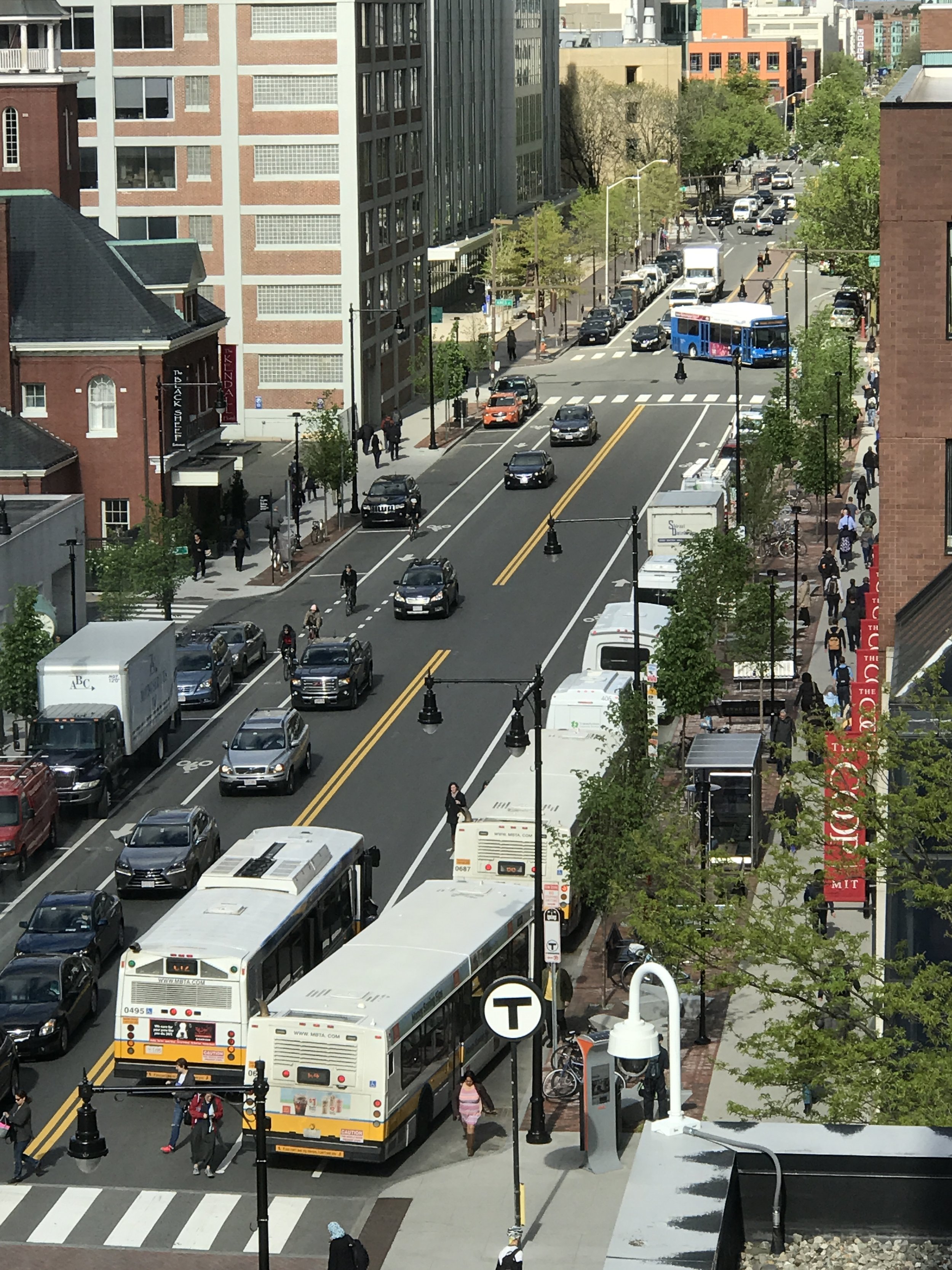
Image of Main Street, busy with buses, cars, and people walking and biking.
Main Street was recently reconstructed in 2015. The section of Main Street reviewed in this report extends from the intersection of Vassar and Galileo Galilei Way to its intersection with Third Street and Broadway.
At the heart of this block, where Carleton Street previously connected to Main Street, lies Kendall Plaza and the MBTA headhouses. This space is a central landing point for people arriving at Kendall Square from rapid transit and numerous bus services, and the plaza’s role as a pedestrian hub is only increasing due to the new public stairway accessing the UP Roof Garden and the upcoming opening of Kendall Public Market. With the public easement through the Marriott Hotel connecting to Broadway in the north and the pedestrianized Carleton Street connecting to SoMa buildings and open space to the south, this section of Main Street is a crucial mixing zone for people of all different travel modes.
Through the design process for Main Street, the streetscape area was separated into two sections. The first section includes Main Street west of Ames Street, between Galileo Galilei Way and Ames Street, and the second section includes Main Street east of Ames Street, between Ames Street and Galaxy Park.
For the second section east of Ames Street, three streetscape design options were considered to accommodate bicycle facilities while still accommodating needs for convenient bus service, pedestrian access to Kendall Plaza and the MBTA Headhouse (entrance), customer and loading access to the ground floor retail, and restaurant uses and vehicular access to the south side of the street.
GOALS ESTABLISHED WITH THE PUBLIC & STAKEHOLDERS
Provide a transformative public transit gateway into Kendall Square
Facilitate highest and best mix of pedestrian and transit use
Incorporate separated bicycle facilities
Reconcile need for loading with public realm improvements
Main Street - West of Ames Street

-
For Main Street between Ames Street and Galileo Galilei Way, the proposed streetscape design includes protected one-way bike lanes on each side of the street. The existing median would be removed to allow for the protected bike lanes to be installed without significant impact to the existing parking and trees. These bike lanes would connect to the existing separated bike lanes on Vassar Street and proposed separated bike lanes on Galileo Galilei Way as well as the on-street bike lanes to the west on Main Street.
Ideally, the bicycle facilities on Main Street should be raised to provide the greatest level of cyclist comfort and protection. Further study is needed however to understand the feasibility of raised bicycle lanes due to the depth of the redline tunnel, and concern relating to the relocation of utilities and drainage.
Main Street - East of Ames Street, Option A - Center Bike Lanes

-
This option would consist of a 10-foot-wide separated bi-directional bike lane (5 feet wide in each direction) with flexible barriers, 11-foot-wide travel lanes in each direction, and 8-foot-wide parking lanes adjacent to the curb. This option would also allow for shuttle/bus loading areas on either side of the street. This center bike lane concept was proposed due to the unique alignment of eastern Main Street connecting to Galaxy Park, and the inclusion of a contraflow raised separated bicycle lane to the intersection of Broadway. The bicycle lane barriers providing separation between the two-way bike lane and the vehicular lanes need to be flexible to allow emergency vehicles to drive over them if necessary, as there would be less than 18 feet clear between the parked cars and the barriers in this design.
In order to avoid conflicts between cyclists and turning vehicles, left turn movements into and out of the MIT parking and loading area (Ford Lot), Dock Street, and Hayward Street would not be allowed for westbound traffic. Right turns into and out of these areas would still be possible for eastbound traffic. Because of this, traffic entering these locations from the north on Third Street would need to take a right on Broadway, a left on Ames Street, and another left onto Main Street to access these locations. Traffic headed to the west from these locations would need to head east towards Broadway and take a right turn onto Memorial Drive.
In this option, at the eastern end of Main Street, cyclists would need to transition from a side running bike lane on Broadway to a center running bike lane on Main Street, as described in the previous West of Ames Street section. It may be possible to restrict through traffic on this section of Main Street to reduce conflicts at this location. The bike lanes would also transition to side bike lanes at Ames Street. The pavement markings and traffic signal would need to be modified to provide protection for these movements.

PROS
Allows for more curbside pick-up/drop-off, loading, and parking
Allows for convenient bus/shuttle loading
Allows for more sidewalk placemaking opportunities
Existing curbs could remain in the same location
CONS
Bicycle signal phase needs to be added at Ames Street to allow bicycles to cross through traffic lanes onto side bike lanes to the west
Bicycles need to cross vehicular and pedestrian traffic at raised crosswalks at Galaxy Park onto side bike lanes
Potential conflicts between cyclists and pedestrians at mid-block crosswalk could require pedestrians to stop in crosswalk while crossing motor vehicle lanes
Bike lanes would separate the open spaces on either side of Main Street making the street less inviting to pedestrians
Protection barriers for center bike lanes would prevent left turns into and out of MIT Ford Lot, Dock Street, and Hayward Street
Eastbound semi-trailers would not be able to back into MIT Ford Lot without encroaching on center bike lanes.
Eastbound semi-trailers would not be able to turn into Hayward Street without encroaching on center bike lanes. Semi-trailers would need to enter SoMa loading entrance on Hayward Street from the south.
Main Street - East of Ames, Option B - Side Bike Lanes

-
This option would include protected 6- to 8-foot-wide one-way bike lanes on each side of the street and two 11-foot-wide travel lanes. The bike lanes would be located between the existing trees and the vehicular travel lane protected by a raised curb or barriers. As was discussed in the West of Ames Street section above providing raised protected bicycle lanes is the preferred bicycle facility design, in order to provide the greatest level of cyclist protection.
Further study is needed however to understand the feasibility of raised bicycle lanes due to the depth of the redline tunnel, utilities and drainage.
In this option, the bus/shuttle passengers will need to cross the bike lane to load and unload. This could be done with floating bus stops which would allow passengers to load between the bike lane and the curb or with bus stops where the passengers would cross the cycle track while loading.

PROS
Standard design, easily understood by all users
Turning movements into and out of the Ford Lot, Dock Street, and Hayward Street would not be impacted
CONS
Increased conflicts between cyclists and pedestrians, especially at bus stops, taxi stand, and mid-block crossing
Limited space for pick-up and drop-off, loading, and shuttles
Eliminates most parking on the south side of the street
Buses would stop in travel lane to pick up passengers
As was raised in the Transit Advisory Committee meeting, floating bus stops can be a challenge to make people waiting feel comfortable and need to be large enough to allow for accessible loading and unloading
Main Street - East of Ames, Option C - Woonerf, or Slow Street

-
Due to input received during public outreach, CRA Board meetings and stakeholder conversations, an alternative Option C – woonerf, or slow street design, was proposed. A woonerf is defined as a “living street” where all road users, especially vulnerable users such as people walking and biking, share more equal priority in space and design. This option presents the road as a more natural transition between adjacent public realm spaces and aims to slow vehicle traffic and so that cyclists and vehicles may safely share the street rather than providing dedicated space for each. It also allows for placemaking opportunities, such as pocket parks, additional fixed or movable seating, moveable planters, public art installations, and specialty paving to make this section of Main Street feel like a destination, not just a passageway.
This option would include various traffic calming measures to reduce vehicle speeds and would also include signage to indicate that this section of the street is intended only for local traffic. Traffic calming measures could include raised pavement grades, narrower travel lanes, unique pavement markings to make the travel lanes feel narrower, and street furnishings, such as planters, to designate pedestrian spaces within the street. These traffic calming measures would still allow vehicle access to local businesses for parking and loading, but would provide a signal to drivers that the travel lanes are shared with other users and would encourage non-local traffic to follow other routes. Loading areas would be limited to locations where off-street loading is not available. Designated drop-off spaces would be provided for taxis and rideshare/transportation network companies (TNC) to discourage blocking of narrow lanes.
As noted, this design option was proposed as a way to respond to feedback heard during the public engagement process. Input collected from residents included comments asking for a more pedestrian-oriented design on Main Street. The woonerf concept also addresses concerns from MITIMCo related to Option B (the side-bike lane concept), which significantly limits curbside uses for retail, including pick-up and drop off opportunities and parking; it also addresses their concerns for Option A (the center-bike lane concept), which restricted certain turning movements for their parking and loading facilities at the Ford Lot, at Dock Street, and at Hayward Street. Additionally, during the Transit Advisory meeting, members noted that floating bus stop islands, which would be part of Option B’s side-bike lane design, felt less comfortable and protected than the conditions presented in Option C.
PROS
Reduced traffic speeds and volumes would improve safety and comfort of pedestrians
Facilitates placemaking opportunities to make Main Street a destination, not just a through route
Expanded space for retail outdoor seating
Helps to link new open spaces at SoMa project and 325 Main Street
Allows for more curbside pick-up and drop-off
Turning movements into and out of the Ford Lot, Dock Street, and Hayward Street would not be impacted
Provides for enhanced space for bus stops, and eliminates the need for floating bus islands
Generally received best support from public and stakeholders in favor of this option
CONS
May be confusing to drivers
May not be as comfortable for slower or less experienced cyclists
Would require review by City Council to confirm compliance with the Cycling Safety Ordinance standards

After significant discussion around the three options for Main Street east of Ames, it is clear that further collaboration and study is needed to finalize and select a design direction for the western portion of Main Street. In this study, the three streetscape design concepts offered were discussed and reviewed during public engagement, stakeholder and working group meetings, and each offer benefits to certain modes of transit and curbside uses while creating drawbacks for others. After reflection on community and stakeholder input, however, it is the design team’s recommendation that, for a long-term vision of Main Street, Option C- woonerf, is given primary consideration. This type of design honors Main Street’s evolution as a destination location while facilitating placemaking opportunities for local retailers and businesses. This design was a direct response to community input heard on the original side and center bike lane design options and was well-received by members of the public and stakeholders, as well as the CRA Board. The design team would recommend a slow-street concept only as a complete long-term build and after further traffic study. Before making a firm decision on a design direction, further study is recommended.
PAST Public MeetingS
Cambridge Transit Advisory Committee - April 7, 2021 - presentation
Cambridge Bicycle Advisory Committee - April 14, 2021 - presentation
Broadway / Main / Third Community Meeting - April 28, 2021 - presentation
Cambridge Pedestrian Advisory Committee - April 29, 2021 - presentation
ECPT Presentation - May 12, 2021 - presentation